If you are looking for some of the best trails and hikes in San Franciso, you have landed in the right place. Popular for various adventurous activities like biking, and trail running, San Franciso is also equally popular for hiking trails.
It's a beautiful place where you get to see trails like those with history, city, and nature views. Hence, in this article, we have listed some of the best hikes and trails in San Francisco and they are:
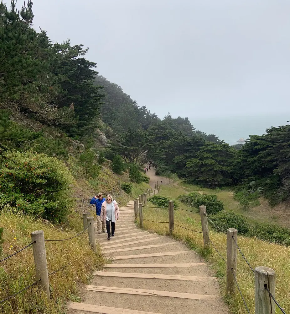
1. Lands End Trail
The popular Lands End hiking trails in San Francisco are a favorite among both locals and tourists because they give fantastic vistas of the Pacific Ocean and the Golden Gate Bridge while also exploring the ancient Sutro Baths.
An essential sight for any traveler to San Francisco. In addition to the neighboring Mile Rock Beach, Fort Miley, the Palace of the Legion of Honor Museum, the USS San Francisco Memorial, the visitor center, and more, hikers and walkers can explore these locations.
Hiking trails at Lands End provide a cliff-top stroll amid open grass and black cypress, with views extending thirty miles along the California coast.
- Length: 5.5 km
- Elevation gain: 169 m
- Route type: Loop
- Difficulty Level: Moderate
2. California Coastal Trail: Lands End to Golden Gate Bridge
The Coastal Trail offers a dramatic trip along San Francisco's coastline, connecting the Cliff House to the Golden Gate Bridge. Stunning cliffs overlooking the Pacific Ocean with waves slamming against the rocks and sailboats sailing past may be found in this lesser-known but equally magnificent spot.
Additionally, you'll be treated to expansive views of the Marin Headlands and the Golden Gate Bridge. You are free to stray from the path, hike for shorter distances, or discover undiscovered beaches along the way.
- Length: 7.2 km
- Elevation gain: 202 m
- Route type: Point to point
- Difficulty Level: Moderate
3. San Francisco Crosstown Trail
The Crosstown Trail in San Francisco is a great place to explore the city if you're seeking hiking trails, parks, secret pathways, and more. Hikers and bikers can explore San Francisco's offerings by traveling the crosstown trail. Lands End is where the trail concludes, having started at Candlestick Point.
Take in the various vistas this trail has to offer as you make your way throughout San Francisco, including the stunning Moraga Steps. If you start early, people have reported that this path takes the majority of the day.
Since there are public transportation options along this trail, hikers have the option to forego hiking the entire length of it.
- Length: 27.2 km
- Elevation gain: 603 m
- Route type: Point to point
- Difficulty Level: Hard
4. Seal Rocks Beach
One of San Francisco's most exquisite beaches is Seal Rocks Beach and there are breathtaking views of the Golden Gate Bridge and the shoreline from this walk. It leads to Point Lobos and the USS San Francisco Memorial, and it's close to Sutro Baths.
This location is well-liked for its stunning view and photos. There are some stairs and a mixture of dirt and partially paved areas. It is advised to arrive early because parking can be scarce on weekends. Near the parking lot are restrooms and a visitor and gift center.
- Length: 3.5 km
- Elevation gain: 110 m
- Route type: Out & back
- Difficulty Level: Easy
5. Batteries to Bluffs Trail
Hikers can explore historic gun batteries, seeps and springs, coastal plants and wildlife, and breathtaking views along the rough Batteries to Bluffs Trail, which winds along cliffs facing the Pacific Ocean.
This short walk offers spectacular views of Marin and the Golden Gate Bridge, making it an excellent way to explore the cliffs surrounding Presidio. If you choose to make the short detour down to Marshall Beach, a peaceful, secluded spot encircled by rocky, serpentine cliffs with breathtaking vistas of the Golden Gate Bridge, there are multiple sections on the walk that require climbing.
If you want to see the Golden Gate Bridge's lights and a lengthy sunset over the Pacific Ocean, try hiking this walk close to dusk.
- Length: 3.7 km
- Elevation gain: 136 m
- Route type: Loop
- Difficulty Level: Easy
6. Bay Area Ridge Trail: The Golden Gate Bridge to Marin Headlands
One of the most spectacular and popular locations in the world is this well-known bridge span, which was dedicated in 1937. Visitors have a wonderful opportunity to learn about the topography of the Bay Area and the path of the Bay Area Ridge Trail by taking a walk, bike ride, or through a wheelchair.
Wear layers of clothes because it can get windy and/or misty on the bridge. A wheelchair-accessible ramp with handrails and a gradual slope leads from the south end of the Visitors Center to the bridge entry.
Once on the bridge, the walkway is flat, usually at least six feet wide, and is paved with cement with steel parts. On the bridge, a safety barrier keeps bikers and pedestrians safe from oncoming cars.
- Length: 2.7 km
- Elevation gain: 73 m
- Route type: Point to point
- Difficulty Level: Easy
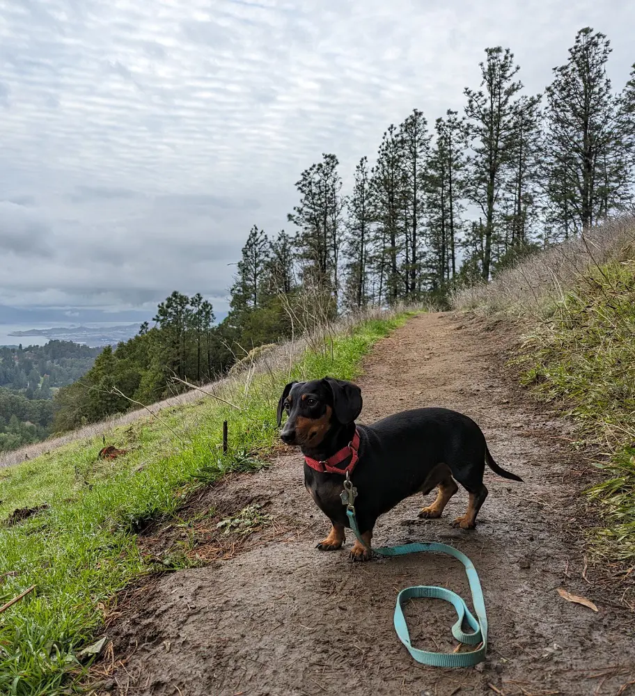
7. Mount Sutro Loop
The Mount Sutro Loop is a 3.5-kilometer-long loop trail located close to San Francisco, California. Hiking this trail is rated as moderately difficult, and it usually takes one hour and nine minutes to complete.
Since this track is well-liked by runners, mountain bikers, and hikers, you will most likely run into other outdoor enthusiasts. The trail is well-known for its breathtaking scenery and is open all year round. Please make sure your dog is leashed if you intend to bring it.
- Length: 3.5 km
- Elevation gain: 152 m
- Route type: Loop
- Difficulty Level: Moderate
8. Presidio Loop Trail
A lovely trail that offers solitude, natural splendor, and the rich history and cultural diversity of the Presidio is the Presidio Loop Trail. This journey offers sensational vistas as it passes through grasslands and woodlands and along coastal cliffs.
This route starts in the Pacific Avenue parking lot and proceeds east on the Mountain Lake Trail, though there are other places to start the loop. Before long, you'll turn left onto Lovers Lane and follow the meandering walk among the enormous eucalyptus trees.
The journey's western segment passes via the SF National Cemetery and around the Presidio Golf Course.
- Length: 9.5 km
- Elevation gain: 234 m
- Route type: Loop
- Difficulty Level: Moderate
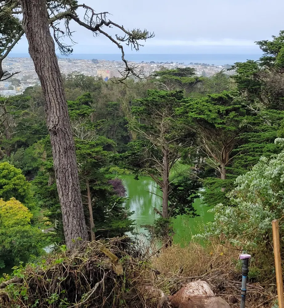
9. Golden Gate Park Loop
The third-most-visited park in the US, Golden Gate Park Loop, is an enormous urban park with a range of well-liked attractions. There are numerous family-friendly hiking paths in this park. The Japanese Tea Gardens and the deYoung Museum are two other attractions.
A wide range of plants and animals may be found at Golden Gate Park, including the park's native California Live Oak tree. These oaks are located in the park's northern region.
Golden Gate Park is the place to go if you're searching for a trek, a picnic space, or a variety of museums and gardens because it organizes events all year long.
- Length: 11.1 km
- Elevation gain: 113 m
- Route type: Loop
- Difficulty Level: Easy
10. Glen Canyon Park Loop
Stunning springtime wildflower displays, striking rock formations, and Islais Creek is one of San Francisco's few naturally flowing streams, that are all found in Glen Canyon.
It was previously known as the San Miguel Hills, this 60-acre wilderness area offers a vital habitat for a diverse range of species and also functions as a tranquil haven away from the hustle and bustle of the city.
Numerous hiking routes wind through different types of environments. The route is lovely to explore at any time of year and is open year-round. Dogs are allowed, but they need to wear leashes.
- Length: 2.9 km
- Elevation gain: 94 m
- Route type: Loop
- Difficulty Level: Easy
11. Redwood Creek Trail – Muir Woods National Monument
With its towering old-growth forest and easily accessible trails, Muir Woods undoubtedly delivers some of the best hiking in San Francisco and is a staple on lists of the city's best hikes. Most guests arrive at the Visitor Center first. From there, Bohemian Grove, Founder's Grove, and Cathedral Grove can be reached by using the Main Trail through the old-growth coastal redwoods.
Redwood Creek is crossed by four bridges. To return to the starting point, cross Bridge 1 and take Bridge 2-4. Your loop will be longer the farther you travel before coming to a bridge. It takes 1.5 hours to complete the 2-mile loop that uses Bridge 4 to access the Hillside Trail or Bohemian Grove Trail.
- Length: 2 miles
- Elevation gain: 30 feet
- Difficulty Level: Easy
12. Stow Lake and Strawberry Hill
Visit Golden Gate Park if you want to spend a moment in nature in the center of San Francisco. Despite being man-made, Strawberry Hill and Stow Lake offer an incredible amount of unspoiled beauty, complete with a waterfall and a tranquil lake teeming with wildlife.
Start at any point in the Stow Lake loop. Enjoy a stroll while searching for ducks, stopping to take photos at the Chinese pavilion, or stopping to get a snack at the Stow Boathouse. Then proceed to Strawberry Hill by crossing one of two bridges.
On your journey to the summit, be sure to stop and observe Huntington Falls so you can get the best perspective of Golden Gate Park.
- Length: 2.1 miles
- Elevation gain: 170 feet
- Difficulty Level: Easy
13. Mori Point Loop Trail – Pacifica
Pacifica and Mori Point beaches are located a short distance south of San Francisco. This lately added area of the Golden Gate Recreation Area features beaches, marshes, and precipitous coastal bluffs. The 1.5-mile coastal cliff trail is a moderately challenging hike, while the 0.5-mile short stroll is also part of the Mori Point trail system.
This region is great for seeing wildlife, including birds and whales, wildflowers in the spring, and serene sunsets away from the hustle and bustle of San Francisco. Pacifica is located thirty minutes south of San Francisco via car. Using BART to Daly City and the 110 bus to Pacifica is a fairly straightforward way to get to Mori Point from the city.
- Length: 1.5 miles
- Elevation gain: 400 feet
- Difficulty Level: Moderate
14. Fort Funston Trail
San Francisco Path for Hiking Dog lovers should hike the Fort Funston Trail. Just outside of Fort Funston, there is a dog-friendly coastal walk called the Sunset Walk Loop.
Everyone will enjoy the peaceful moment by the Pacific Ocean and the many dogs to pet, but history buffs will particularly enjoy exploring the crumbling remnants of buildings from the World War II era.
- Length: 1.67 miles
- Elevation gain: 157 feet
- Difficulty Level: Easy
15. Filbert Steps to Coit Tower
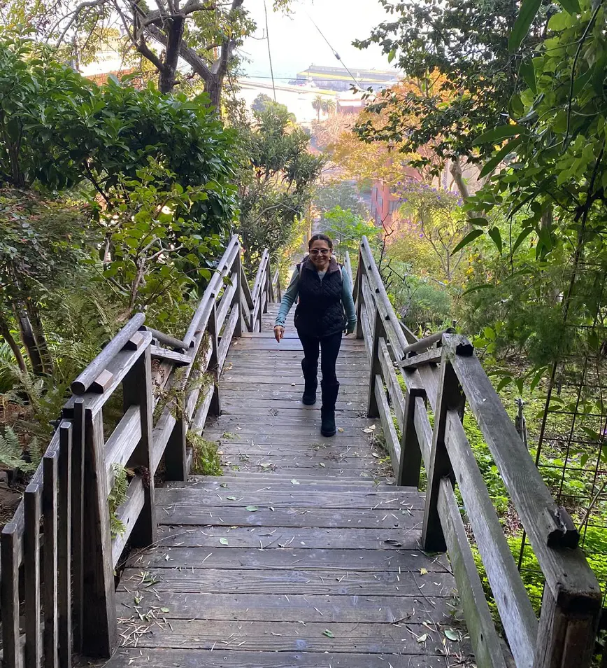
For visitors to San Francisco, the Filbert Steps to Coit Tower trail is incredibly convenient, starting just three blocks up Sansome Street from the Embarcadero. From there, you have to ascend 400–500 stairs to get to Coit Tower's base.
Look for the well-known Telegraph Hill parrots, historical signs, and art deco facades on the surrounding buildings. It's entertaining to watch these boisterous locals relishing the abundance of nature at the Filbert Steps, and they've garnered quite the following.
To access the top of Coit Tower, you must pay a 10-dollar entry charge. There are amazing vistas of the city, the Golden Gate Bridge, and San Francisco Bay to be found.
- Length: 0.5 miles
- Elevation gain: 262 feet
- Difficulty Level: Moderate
16. Twin Peaks
For a magnificent sweeping view of the city, visit Twin Peaks; going up there usually enhances the vista as it is one of the good hikes in San Francisco. Furthermore, the South Peak Parking Lot offers an even better view than the North Peak Parking Lot. At 922 feet, the summit of Twin Peaks is almost as high as the highest point in San Francisco.
Nothing here to obstruct your view of the entire Bay Area, not even houses or trees. There is a mild ascent on the trail through grassland and coastal scrub. It provides you with a clear picture of this area's pre-development state.
- Length: 0.7 miles
- Elevation gain: 400 feet
- Difficulty Level: Moderate
17. Mount Davidson
Mount Davidson, which is located 928 feet above sea level, surpasses Twin Peaks for the city's highest point. A network of pathways winds through native grasslands, eucalyptus forests, and scrub. There are vistas along the short, steep walk up to Mount Davidson.
Perched atop is a 103-foot concrete cross that can be seen all over the city. To honor the victims of the Armenian genocide, this cross was built. From Mt. Davidson, you can see San Francisco's famous districts from a unique vantage point as well as the Twin Peaks.
This viewpoint has fewer people than Twin Peaks, but the views are still amazing and there are more trees.
- Length: 1 mile
- Elevation gain: 242 feet
- Difficulty Level: Moderate
18. Point Bonita Lighthouse
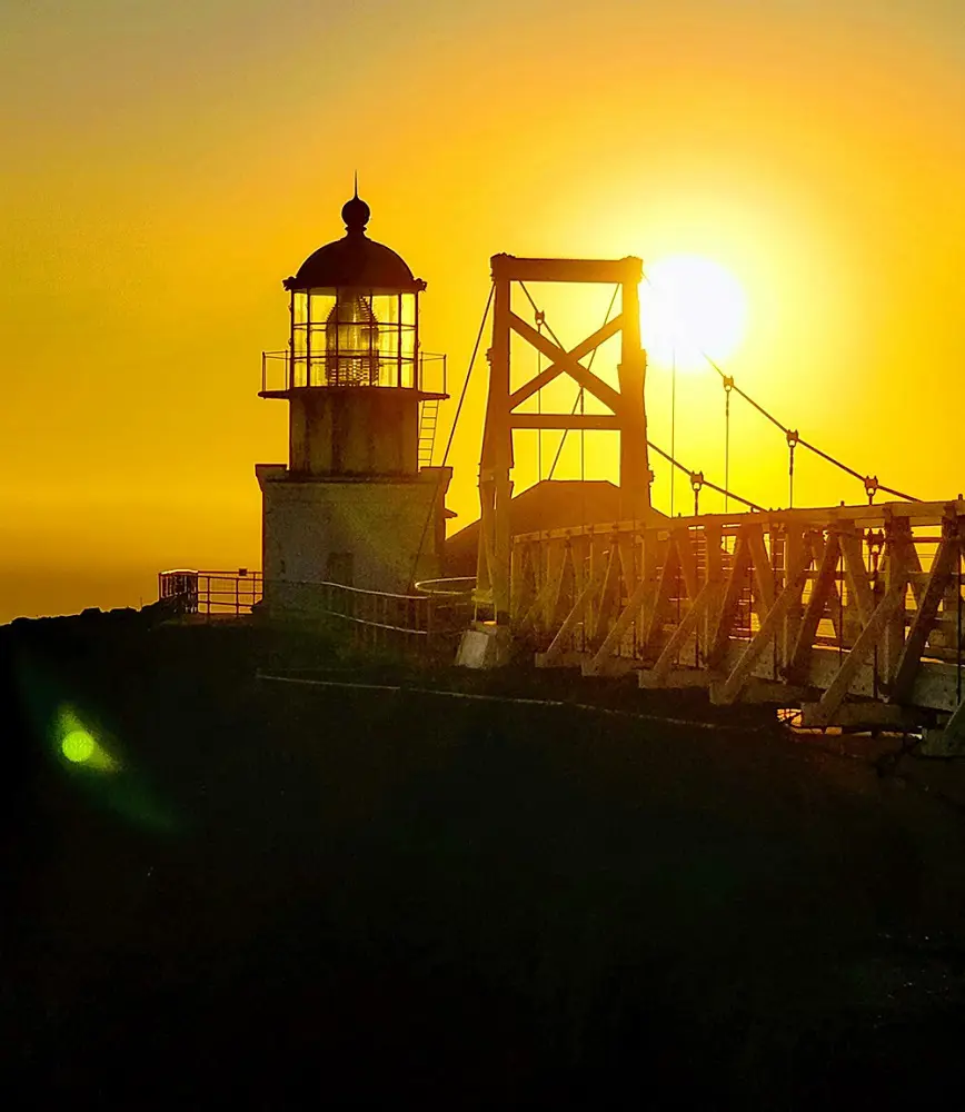
Point Bonita Lighthouse, is accessible by a strenuous climb in the Marin Headlands. The short but a bit rough walk leads to the Point Bonita Lighthouse. The antique lighthouse will be reached when you descend, pass through the tunnel, and cross the suspension bridge.
The working lighthouse is inoperable, but there is an excellent exhibit downstairs. Take in the breathtaking views of the water and search for marine life before returning to the route.
- Length: 1 mile
- Elevation gain: 250 feet
- Difficulty Level: Moderate
19. Battery Spencer Trail
A short stroll through a retired military battery leads to a sensational view of Battery Spencer, as it offers one of the best views of the Golden Gate Bridge, the viewpoint at the end is highly popular.
The view is fantastic, but be sure to spend a good amount of time exploring the area around the former military installation. One of the primary defenses for San Francisco Bay used to be Battery Spencer.
After World War II, a large portion of it was recycled and repurposed. The visit will nonetheless be enjoyable for history buffs even though there is no period weaponry left. For history lovers, this is one of the best hikes in San Francisco area.
- Length: 0.5 mile
- Elevation gain: 39 feet
- Difficulty Level: Easy
20. North Ridge + Sunset Trails – Angel Island
Ferry to Angel Island is a perfect hike that combines the three threats of nature, city views, and history in San Francisco. Known as the "Ellis Island of the West," Angel Island is a breathtaking natural setting with a rich history.
It has served as a U.S. immigration post, a supply point for Spanish explorers, and a hunting site for Coastal Miwok. Discover all that the stunning tiny island has to offer on the 5.9-mile loop that combines the Nature Ridge and Sunset Trails.
The climb offers views of San Francisco's skyline, the surrounding Bay, close-up looks at the island's distinctive ecosystem, and many historically significant locations.
- Length: 5.1 miles
- Elevation gain: 780 feet
- Difficulty: Moderate