Among the largest municipal parks in the US, Griffith Park is one of them and it has unquestionably the best hikes and trails in Los Angeles. It is almost 4 times the size of San Francisco's Golden Gate Park and more than 5 times larger than New York's Central Park.
There are plenty of options for you to hike as trails like Cahuenga Peak, which is the highest point in the park, Mt. Hollywood, Fern Canyon Trail, Griffith Observatory, etc. are a few to not miss out on. We have listed 15 best hikes and trails in Griffith Park for you to explore.
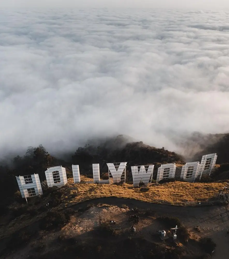
1. Hollywood Sign via Canyon Drive
It is recommended that visitors hike Griffith Observatory or the Brush Canyon Trail, which is accessible via Canyon Drive, two blocks east of Beachwood Drive off Franklin. The canyon features visitor facilities, pathways, trash cans, and parking. It is advised to use the DASH Observatory shuttle as parking at Griffith Park is restricted and tends to fill up quickly.
This wheelchair-accessible bus departs every 15 to 20 minutes from 10 AM to 10 PM. Although it might be for some users, this trail is not wheelchair or stroller-friendly due to several sections with a steep grade of over 12%.
If you're new to the area or visiting, this climb offers fantastic views of the Hollywood sign. A full 360-degree view of the iconic sign may be seen at the summit.
- Distance: 9.7 km
- Elevation Gain: 358 m
- Estimated Time: 2h 57m
- Difficulty Level: Moderate
2. Hollyridge Trail
Hikers following the city's guidelines should head to Griffith Observatory or Canyon Drive, which is located two blocks east of Beachwood off of Franklin. There are parking spaces, walkways, trash cans, and visitor amenities along Canyon Drive.
Due to a court order, the Beachwood Gate, which was once used to access the Hollyridge Trail, was permanently blocked on April 18, 2017. This walk offers fantastic views of the surrounding peaks and the metropolitan skyline in addition to the iconic Hollywood Sign.
There is little to no shade, so please be mindful of the heat as it's really hot there. If at all feasible, hike early or late in the day and carry a lot of water.
- Distance: 8.2 km
- Elevation Gain: 259 m
- Estimated Time: 2h 21m
- Difficulty Level: Moderate
3. Ferndell to the West Observatory Loop Trail to Griffith Observatory
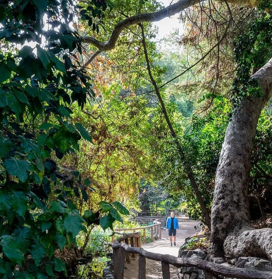
In Griffith Park, Ferndell, sometimes also known as Fern Dell, is a forested valley located at the base of Western Canyon. The famous Griffith Observatory is your destination. For the kind and grade of surface, visitors using wheelchairs, mobility aids, or strollers could require all-terrain tires or powered or adaptive equipment.
There are a few approved accessible parking spots close to the Firebreak Trail to Griffith Observatory trailhead (indicated by a waypoint on the map), but there don't seem to be any along Ferndell Drive near the trailhead.
- Distance: 4.2 km
- Elevation Gain: 187 m
- Estimated Time: 1h 23m
- Difficulty Level: Moderate
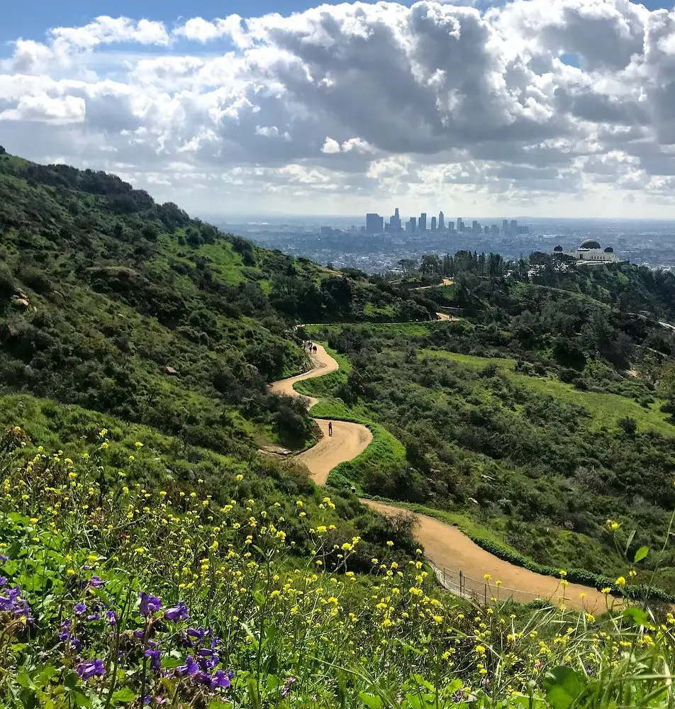
4. Glendale Peak via Riverside, Hogback, and Mount Hollywood Loop
This well-liked urban hike in Griffith Park provides breathtaking views of the city. This route offers little to no shade, so be sure to pack plenty of water, a hat, and sunscreen. The most popular summits on this hike are Dante's View and Glendale Peak.
From this route, you can also choose to make an optional detour to the summit of Mount Hollywood. This is a 5.8-kilometer path that takes about two hours to finish. August is generally known for high temperatures and little shade, so it's best to go on walks early in the morning or late in the afternoon to avoid the heat.
- Distance: 5.8 km
- Elevation Gain: 254 m
- Estimated Time: 1h 54m
- Difficulty Level: Moderate
5. Griffith Park Old Zoo Loop
This Griffith Park Old Zoo Loop is a dirt trail with a variety of topography and moderately steep slopes. There is hardly much signage on this trail, so come prepared. For the kind and grade of surface, visitors using wheelchairs, mobility aids, or strollers could require all-terrain tires or powered or adaptive equipment.
There are six approved van-accessible parking spaces with striped access aisles in Merry Go Round Lot Three (indicated on the map with a waypoint), but there is no allocated accessible parking near the trailhead. The trail's natural (soil) surface is usually at least eight feet wide.
- Distance: 4 km
- Elevation Gain: 114 m
- Estimated Time: 1h 6m
- Difficulty Level: Easy
6. Mount Hollywood Trail
The Hollywood sign and Griffith Observatory are visible from this trail. There are steep parts of the trail, and after rain, it can get slick. In these areas, proceed with caution. The trail is kept up and clearly marked as it is one of the best hiking trails in Griffith Park.
Look for beautiful wildflowers blossoming in the springtime along the walk. This is an excellent hike for sunrise or sunset. The approximately 3-mile, somewhat challenging course should be finished in one and a half hours.
- Distance: 4.8 km
- Elevation Gain: 152 m
- Estimated Time: 1h 23m
- Difficulty Level: Moderate
7. Cahuenga Peak via Burbank Peak Trail
The Burbank Peak Trail leads you to Cahuenga Peak (1,821 feet) in Griffith Park on this hike. Despite the trail's short length, expect a continuous, sharp descent and climb that includes a rough scramble. Views of Los Angeles and the rear of the Hollywood sign will greet you as a reward.
You can proceed to the sign once you've reached the peak. Bringing trekking poles for the descent and donning supportive hiking boots are highly advised. The trip is 2.3 miles long and takes about an hour and a half to complete due to its moderate difficulty.
- Distance: 3.7 km
- Elevation Gain: 262 m
- Estimated Time: 1h 34m
- Difficulty Level: Moderate
8. Captain's Roost via East Observatory Trail
Griffth Observatory, Astronomers Monument, Berlin Forest, and Captain's Roost are all accessible from this location via the East Observatory Trail that leads to the Charlie Turner Trail. The public can access Griffth Observatory for free, although parking is charged.
You will be stunned with stunning vistas of Los Angeles and the Hollywood Sign as you hike. There is a gentle climb on this trail leading to Captain's Roost. Due to loose ground, several areas are sand-like and resemble a scramble.
- Distance: 6.6 km
- Elevation Gain: 247 m
- Estimated Time: 2h 0m
- Difficulty Level: Moderate
9. Hogback Trail to Mount Hollywood
This amazing trail, which connects to Mount Hollywood via the Hogback Trail, is located close to Los Angeles. This trail winds over difficult, rugged terrain with rocky and scramble-like conditions. It starts with a high ascent and gets considerably steeper near the conclusion.
Views of Los Angeles and the iconic Hollywood Sign are quite striking from this location. At dawn and dusk, when orange lights dance across the horizon, these sights are even more breathtaking.
Not only does this site offer breathtaking vistas, but it's also quiet and serene, away from the nonstop activity of the never-ending metropolis of Los Angeles. Hence, it takes almost 3 hours to complete this 5.71 miles of distance.
- Distance: 9.2 km
- Elevation Gain: 398 m
- Estimated Time: 3h 0m
10. Riverside Trail to Vista Viewpoint
This is a fantastic urban hike with lovely scenery. For fantastic views of the City of Los Angeles, hike to Vista Viewpoint. Water and sun protection should be brought as there is not much shade throughout the route. The trail is a broad, densely packed dirt path with a combination of level sections and steep inclines and descents.
Being one of the simplest, this well-liked trail and the trailhead frequently fill up, so get there early. Even though the difficulty level is easy, the Riverside Trail is approximately 4 kilometers long and takes slightly more than an hour to complete from Vista Viewpoint.
- Distance: 4 km
- Elevation Gain: 124 m
- Estimated Time: 1h 8m
- Difficulty Level: Easy
11. Fern Canyon Trail
Though steep, the Fern Canyon Trail hikes in Griffith Park provide breathtaking views. Late spring and early summer bring vibrant blooms along the trail. If you want more privacy and self-time, try hiking during the week or arriving early on this well-liked trail. It's a lovely place to view the sunset, and dogs are welcome.
Additionally, keep in mind that there isn't much shade, so getting an early start is advised. Hikers enjoy cool views from some higher locations and moderate inclines with steep and rocky areas.
The ground is dirty, and horse dung has been observed, which may make the fall slick. August is usually a warm, dry month that calls for lots of water and sun protection. Hence, it will take a bit more than 1 hour to complete the trail.
- Distance: 3.7 km
- Elevation Gain: 140 m
- Estimated Time: 1h 8m
- Difficulty Level: Moderate
12. Boy Scout and Observatory Trail
You have to try this 2.3-kilometer trail that circles back towards Los Angeles, California. It takes an average of 46 minutes to complete and is generally regarded as a moderately hard course. Since this is a very well-liked hiking and walking destination, you will probably run into other visitors while exploring.
The route is lovely to explore at any time of year and is open year-round. Because of this, although the trail's opening section is steep, the entire journey is worthwhile. Since August typically sees high temperatures, hikers should pack drinks and sun protection.
- Distance: 2.3 km
- Elevation Gain: 110 m
- Estimated Time: 0h 46m
- Difficulty Level: Moderate
13. Observatory Trail Extended Loop
This is a fantastic loop that offers pleasant vistas as it circles Griffith Park. The Hollywood Sign can be seen in certain places, and Griffith Observatory is passed by on the trail. Visit the observatory and take in the displays when you take a break from your hike. You can hike the loop in either direction.
Trekking poles are advised because some of the routes are rocky and steep. Hikers can take in breathtaking vistas of the San Fernando Valley and Los Angeles, especially after ascending Mount Hollywood.
August weather in the area is typically warm and dry, so hikers should be sure to pack adequate water and account for the possibility of heat.
- Distance: 9.5 km
- Elevation Gain: 389 m
- Estimated Time: 3h 2m
- Difficulty Level: Moderate
14. Burbank Peak Trail
This lovely spot near the city, which transports one from the bustle of the city into nature, is located in the house of Hollywood. This place is breathtaking, especially considering that it is close to Los Angeles but still entirely green and away from the bustling concrete jungle.
There's a rather steep rise on the summit route, and the rocky, sandy, scramble-like conditions are increasingly more noticeable near the end. For this trek, hiking boots and shoes are highly suggested.
Do remember to bring plenty of water as well, since this region may get really warm. This trail only goes to the rear of the well-known Hollywood sign, but not the front. Still, it leads one away from the masses and offers a very different kind of perspective.
- Distance: 1.8 km
- Elevation Gain: 186 m
- Difficulty Level: Moderate
15. Mineral Wells
This trail mounts to an amazing vantage point overlooking the Los Angeles skyline. There are benches to relax on and take in the scenery at several points along the loop. The wide, picturesque routes on the relatively level, paved Mineral Wells trail in Los Angeles provide an excellent exercise at the beginning.
You may see wildflowers growing along the hillside in the spring. The trail is wide enough to stroll by a trekking partner for the most part. August usually brings hot weather and little shade, so bring plenty of water. All in all, the trail has stunning views, although seasonal wildlife needs to be observed.
The Mineral Wells trail is around 6 miles and it takes around 2 hours and 40 minutes to finish the hiking.
- Distance: 9.7 km
- Elevation Gain: 274 m
- Estimated Time: 2h 39m
- Difficulty Level: Moderate